- This page is about the schematic map. For the network, see Stepford County Railway.
SCR's network map has been a core part of the game since it first opened.
For every operator when the player is driving, they can pull up an operator-specific map which shows the stations that the operator stops at.
The map below is interactive: click the stations or operators to see the pages.


.png)
How to view[]
Press M (or 1 when driving) on the keyboard to show it while the player is a passenger. The map of the different services of that operator will be shown if the player is driving a train, otherwise the whole map of Stepford County Railway will be shown instead.
The map will show up with a white base during daytime in-game, and with a dark base instead during nighttime.
Trivia[]
- It has undergone many changes over the years, and many of the older maps have little to no documentation.
- In the early days of SCR, unopened sections appeared on the map, meaning that some information was leaked, for example, the Llyn-by-the-Sea extension (also known as the Llyn Extension for short).
- Stepford Victoria and Financial Quarter are parallel to Stepford Central and City Hospital, however, the map didn't show this accurately until V1.6.
- Though in V1.9, the map was redesigned and the Stepford Victoria Branch was now geographically incorrect.
- In V1.10, the maps were redesigned again, but still not as accurate as the V1.8 maps.
- One of the Class 68 and Class 444's exclusive routes, R036, as well as the free route R045 are not mentioned on Stepford Connect Network Map.
- Stepford Central is the first and currently only station to have the network map inside it. It is located near the Approach Road entrance by the staircase that leads to Platforms 11 and 12-15.
- Before V1.7, R079 was not displayed on the Stepford Express map.
- Prior to V1.8, R009 was not shown on the Stepford Connect map.
- When V1.5.0 was released, the network map could not be loaded. When a player pressed
Mor the icon on the driving GUI, only a dark frame would appear.- This was subsequently fixed after a server reboot on 24 May 2020, however, the maps were still the same as in V1.4, with the old version number and Operator logos.
- Similarly, this also happened with the release of SCR Version 1.10, due to the new maps not being ready yet. They were later added in on the 1st September.
- This was subsequently fixed after a server reboot on 24 May 2020, however, the maps were still the same as in V1.4, with the old version number and Operator logos.
- The Connect and Network maps were updated in V1.6 to include the new Willowfield extension and the rebranded Stepford Connect logo.
- However, until V1.6.2, the Waterline map in-game was not updated and was still in V1.4 without the Morganstown Shuttle, plus showing the old WaterLine logo before rebranding, with the sentence "part of your Connect Service" in it. Instead, the Network map already showed the shuttle even before it actually opened.
- As there were no changes to the network of Stepford Express and AirLink, their route maps were still the V1.4 ones up until V1.7.
- However, until V1.6.2, the Waterline map in-game was not updated and was still in V1.4 without the Morganstown Shuttle, plus showing the old WaterLine logo before rebranding, with the sentence "part of your Connect Service" in it. Instead, the Network map already showed the shuttle even before it actually opened.
- All network maps (including the operator maps) were known to be bugged, such as Waterline and AirLink maps failing to appear and other maps bizarrely splitting into two upon appearing. This was fixed in V1.8.

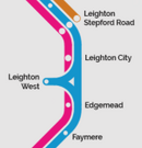
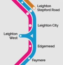
- When V1.8 was first released, the bright version of the network map incorrectly featured no station 'blobs' at Leighton City and Edgemead for Stepford Connect despite stopping there, possibly due to an oversight with adding the new Leighton West Branch. This error did not occur on the dark version of the map.
- It was later quietly fixed when using the GUI, however the error remained on the large map at Stepford Central until it was patched in V1.8.4.
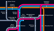
A portion of the second redesign of the network map, sneak peeked by Head of Brand Design tpx_jm on 15 May 2022
- A sneak peek on 15 May 2022 revealed a redesign of the network map. This included redrawing the lines for the operators and the Ubuntu font replacing Raleway.
- The redesigned network map was added in V1.9.
- The redesigned network map received lots of criticism, with players stating that it was overcomplicated and highly ungeographical.
- In V1.10, the network and operator maps failed to be released on time with the update. Consequently, the maps did not show up in the GUI, and the large map at Stepford Central still displayed the V1.9 network map.
- The Terminals Shuttle and the Class 345 is the only route and train to have their own unique route map, being part of the AirLink Shuttle.
- Although the new V1.10 network map shows James Street as a limited-service station, the Waterline operator map shows James Street as a regular-service station on the Esterfield Branch.
- According to Product Developer tpx_jm, this is to show clearly that there are services that skips James Street on the network map. Although 2 of the 3 routes stop at this station (and not less than 50% of routes), this station is not shown as limited in the Waterline operator map.
- Many players have thought that this should also apply for East Berrily, as only R007 (Stepford Central <> Morganstown) stops there while the other route (R034 (Beechley <> Morganstown) skips it, being part of the 50% of routes skipping that station.
- According to Product Developer tpx_jm, this is to show clearly that there are services that skips James Street on the network map. Although 2 of the 3 routes stop at this station (and not less than 50% of routes), this station is not shown as limited in the Waterline operator map.
Past Maps[]
Network Map[]
")
")
")
")
")
")
")
")
")
Stepford Connect Map[]
")
")
")
")
")
")
")
")
")
Waterline Map[]
")
")
")
")
")
")
AirLink Map[]
")
")
")
")
.png "AirLink Map (Fixed).png (182 KB)")
")
.png "AirLink Map (V1 4 1).png (192 KB)")
")
")
")
")
")
")